


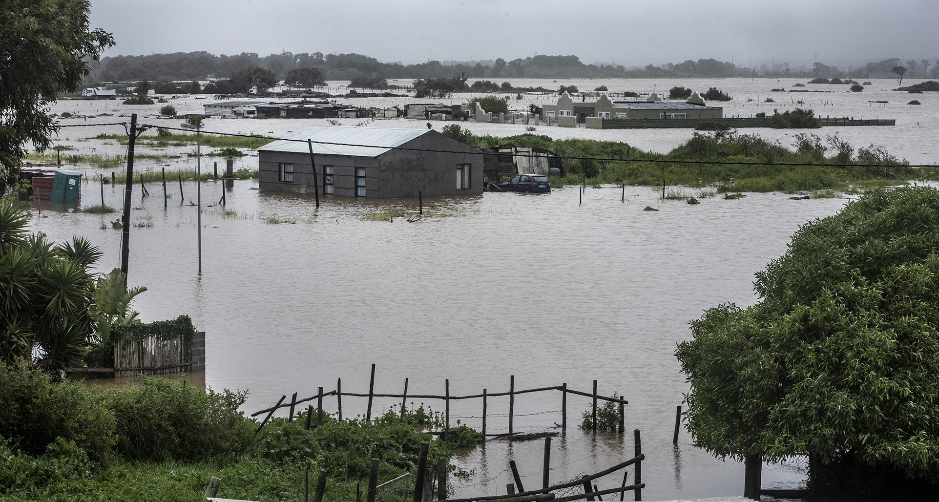
 Flooded homes on 25 September 2023 in Sandvlei, Western Cape. (Photo: Benton Geach / Gallo Images)
 Over the weekend in the Western Cape, nature’s fury was unleashed with seemingly unprecedented intensity, with rooftops ripped off, roads submerged and communities cut off from the outside world. In what is almost certainly the wettest year in the province’s recent history, the Heritage Day weekend saw more rain in three days than in the previous two months.
But what exactly caused all of this and how normal or abnormal is it?
/file/dailymaverick/wp-content/uploads/2023/09/Main-Kalk-Bay-1.jpg "In the Kalk Bay area, a spectacle unfolded as huge waves pounded the harbour. As these surged skyward, bystanders erupted in panic, with successive ‘watch outs!’ echoing through the salty sea spray. (Photo: Kyra Wilkinson)")
In conversations with Daily Maverick, Dr Peter Johnston, a climate scientist and research officer at the University of Cape Town’s Climate System Analysis Group (CSAG) and Kate Turner, a forecaster at the South African Weather Service (Saws) explained why the Western Cape was rocked by wet and windy weather.
Read more in Daily Maverick: Downpours and gales wreak havoc across Western Cape over the heritage weekend
A ‘cut-off-low’
The Saws, after issuing an Orange Level 9 warning, explained that from Saturday night, a “cut-off low-pressure system” — the equatorward displacement of a low-pressure system at high altitudes — developed along the west coast of South Africa. That system intensified by Sunday as it entered the country’s western interior, causing bursts of intense rainfall, flash flooding, strong winds and very rough seas.
A cut-off low is a “type of weather system that develops in the upper air causing showers and thundershowers”, Turner explained.
“These kinds of lows can be very severe. They can range from almost not affecting anything to … very severe; they’re one of the most intense systems that we could potentially get over the country. So this is not uncommon for us. But yes, this was definitely a very intense system that moved over, over the last couple of days.”
Johnston expanded on this definition.
/file/dailymaverick/wp-content/uploads/2023/09/ED_468419-1.jpg "Sir Lowry's Pass above Somerset West was closed for hours due to fallen trees on 25 September 2023. Disaster management officials have been working round the clock amid reports of flooded roads, damaged homes, uprooted trees and power outages. (Photo: Benton Geach / Gallo Images")
A cut-off low is “a depression, which means it’s a low-pressure system with rising air being drawn up into the upper atmosphere and it can be very intense in that this rising air can carry a lot of moisture coming off the ocean. It carries a lot of moisture, forms a lot of clouds.
“It’s like a frontal system, but this is being cut off from what we call the flow towards the east of the frontal system. Normally, frontal systems will pass us and then they’ll move quite quickly towards the east. And this little system is cut off from that flow and so it stays semi-stationary. So it hangs around and it’s very unpredictable. It doesn’t move as quickly as a frontal system and therefore if it decides to start raining in a place, it can keep raining there for two or three days,” he explained.
“It’s very strong. It’s very powerful,” but, “it’s not a hurricane. It’s not a tornado,” Johnson was careful to stress.
Put simply, this atmospheric orphan, detached from the flow, when parked in one generalised location can lead to prolonged and intense rainfall. It was this obstinate system that brought about the downpour, resulting in meteorological mayhem over the Western Cape this weekend.
‘It’s been phenomenal’
But just how intense was this weekend’s weather, according to the science and historical precedent? Johnston had the answers.
“When we use models and projections, we have projections of what’s going on in the upper air … about three to five kilometres up in the sky, and we measure what’s going on there and if the pressure up there is very low, then we know that the system is very deep.
“So this system is extending quite high in the sky and the air is therefore moving upward, and as it’s moving upwards, it’s drawing more air with it and more moisture and therefore we can determine how strong it is and how much rain there’s likely to be.
“So it’s really the strength of the system which is measured by the height at which it’s being shown on the charts and this height of the system will indicate how much condensation is going to take place and therefore how much rain the system can hold,” he continued.
“If a system is isolated to just the upper atmosphere, we probably won’t have any rain and if it’s isolated to just the lower part of the atmosphere, then we get very little rain and it passes very quickly.
“But when it connects from the lower to the upper atmosphere and is very deep — that is, the atmospheric depth of the system that we use to measure — and if that’s very high, then we will see very, very high rainfall and that’s exactly what we’ve had.
/file/dailymaverick/wp-content/uploads/2023/09/ED_385778.jpg "A pedestrian tries to cross Spine Road in Cape Town after a section of the road surface between the N2 and Mfuleni was washed away on 15 June 2022 after a cold front moved over the Western Cape. (Photo: Gallo Images / Die Burger / Jaco Marais)")
“We’ve had more rainfall over the last three days than we have in two winter months, so it’s been phenomenal.”
Turner from the weather service confirmed this, saying that in just two days the Cape Winelands and Stellenbosch received more than 193mm of rain. The City of Cape Town had 143mm of rainfall over the same period.
Turner added that while the intensity may vary, “These kinds of flows generally occur during our changeover seasons. They’re not confined to our changeover seasons, but it is during the spring and autumn that these are most often occurring.
“We’ve had a number of drier seasons for the last couple of years, where we are increasing in terms of amounts of rainfall through the winter and into the springtime, but definitely this year has been the wettest season in the last 10 years.
“So it’s not uncommon,” she clarified. “But it hasn’t been as intense as what we’ve experienced over the weekend and in a fair number of years.”
Daily Maverick reported in June that Dr Piotr Wolski, the chief research officer for hydroclimatology at CSAG, said, “If we look at total rainfall between January and now … at some locations, this year’s values are the highest on the recent record (we are looking at 20-40 years of data here)”.
Read more in Daily Maverick: Western Cape: Rainfall this year is breaking records in SA’s ‘most disaster-prone’ province
It was not only the rains that caused havoc. Wild, whipping winds wrought wreckage, from the Winelands to Wynberg.
Johnston explained that according to measurements taken with his personal at-home weather station, wind gusts reached up to 68km/h.
“Those sort of gusts are very damaging and that’s what blew the trees down and roofs and things off,” he added.
‘Most disaster-prone province’
While scientists like Johnston can shed light on the mechanics of such events, attributing specific weather events to climate change remains a complex task.
Daily Maverick has reported that Western Cape local government, environmental affairs and development planning MEC, Anton Bredell, said the province is characterised by a highly variable weather and climate system. This means it has always, and will in future, experience all manner of extreme weather and climatic events including flooding, drought and extreme temperature.
“The Western Cape is the most disaster-prone province in South Africa, and is particularly vulnerable to climate change and the effects of climate-related hazards because of its coastal location, with rising sea temperatures expected to influence regional weather patterns,” said Bredell at the time.
Studies have found that at least 334 major flood events occurred in the Western Cape between 1900 and 2018, with roughly three events occurring in any given year. However, this varies — in 2008, the province experienced 20 floods, and 15 in 1981, he noted.
He said that statistically it appeared that in recent years there had been a trend towards more flood events.
Climate change makes extreme rain more likely
Flooding has also been identified in the Western Cape Climate Change Response Strategy: Vision 2050 and its Implementation Plan as one of the many areas of concern.
The Western Cape government expects that the natural variability in the weather patterns of the Western Cape is likely to intensify because of climate change, causing flooding and droughts.
Read more in Daily Maverick: The city that blows hot and cold – Cape Town’s flood-drought dichotomy explained
Speaking about the role of human-induced climate change in this weekend’s weather, Johnston explained that while there was no established causal relationship at present, as Earth’s temperature continued to rise due to the accumulation of greenhouse gases, we would see more intense and unpredictable weather patterns.
Rising sea surface temperatures and increased atmospheric moisture content contribute to the formation of cut-off low-pressure systems, like the one which caused so much destruction in the Western Cape this weekend.
“Because of global warming, the climate system is more active and that’s the reason why we’re seeing more intense rainfall events all around the globe. The rain seems to be more intense because the Earth is warmer, there’s more water evaporating into the atmosphere and there’s more water available then for rain to occur,” he explained.
“So this is the main issue and climate change may not be directly responsible for what happened this weekend, but it is making conditions suitable for heavy rainfall more likely. So there’s always a higher likelihood of extreme rainfall as the temperature increases and this is what we’re seeing. We know that the temperature is increasing. We see it every decade, there’s no doubt about it whatsoever.” DM