WILD COAST TOLL ROAD
Sanral’s need for speed rides roughshod over Xolobeni/Amadiba community’s land
The Amadiba Crisis Committee has urged Sanral to reroute the new N2 Wild Coast toll road that will cut through their land and harm ecotourism potential. So far, their pleas have fallen on deaf ears.
It has been more than 20 years since a road-building consortium submitted an unsolicited bid to reduce the distance between Durban and East London, by building a shorter, straighter and flatter high-speed route between the two cities.
The new N2 Wild Coast toll road – now under construction via the SA National Roads Agency (Sanral) at a cost of more than R20-billion – aims to shave 80km off the current 550km journey between the two cities by eliminating the current dog-leg route via the inland town of Kokstad.
Instead, a new section of double-lane highway would be built immediately south of Port Edward and travel much closer to the coastline, to link up with the existing N2 route near Mthatha.

The N2 Wild Coast toll road is designed to shave 80km off the current route between Durban and East London. (Map: Sanral)
This straighter coastal route would allow traffic to travel at 120km/h, further cutting travel time by avoiding the current speed restrictions along the more winding and mountainous inland route.
For transport companies and travellers rushing to get from point A to point B as fast as possible, the new route makes obvious sense.
Yet, the proposed N2 Wild Coast toll road proposal has been controversial from the start.
This is partly because the original plan depended exclusively on toll funding and partly because the new shorter route passes through one of the last undeveloped sections of the SA coastline. The Wild Coast.
Mixed finance
The hotly contested toll fee issue almost derailed the project nearly a decade ago. This happened when the KwaZulu-Natal government and several industries in Durban raised vociferous opposition to imposing further toll fees on KZN motorists to subsidise the massive costs of building a new route through the neighbouring Eastern Cape.
When the KZN government refused to budge on toll subsidies, the national government opted to follow a new “mixed-finance” model that would fund the new route from toll fees collected in the Eastern Cape only, with the balance of the funding appropriated through the Treasury.
Now construction appears to be steaming ahead, with at least two major bridge projects well under way.
Construction on the R1.65-billion Msikaba Bridge started in 2019, while a R4-billion contract for the Mtentu Bridge was awarded in November to the China Communications Construction Company and Mecsa Construction joint venture.

An architect’s impression of the new Msikaba bridge (Image: Dissing Weitling Architecture)
According to Sanral, the Mtentu Bridge will be the highest in Africa and also one of the longest main-span balanced cantilever bridges in the world, with a main span of 260m at a maximum height of around 223m.

An architect’s impression of the new Mtentu bridge, touted as the highest such structure in Africa. (Image: Dissing Weitling Architecture)
But no final decisions appear to have been taken on construction timeframes for the most controversial section that passes through the Xolobeni/Amadiba community immediately south of Port Edward.
It is this section – closest to the coastline – that has raised the strongest opposition from the Amadiba community and environmental groups.

Members of the Xolobeni community at a meeting to discuss the impacts of new high-speed roads and dune mining. (Image Suppled)
Negotiating the route
Nearly 20 years ago, the Wildlife and Environment Society urged Sanral to amend its route plan by pushing it deeper inland to protect the coastline from a wave of uncontrolled commercial and residential development.
The Amadiba Crisis Committee (ACC), which was established in 2007, is also strongly opposed to the coastal route.
First, committee members oppose a new 120km/h freeway passing directly through their land, dividing the people and their communal farming and grazing lands.
Second, they fear that the route was chosen deliberately to enable an Australian mining company and local empowerment groups to mine and transport heavy minerals from sand dunes in the coastal Xolobeni area.
Read more in Daily Maverick: Transkei’s Xolobeni community sounds alarm over extractivism, absent ministers and lack of basic services
They argue that the toll road and proposed dune mining venture will permanently wreck opportunities for local communities to benefit from low-impact ecotourism ventures along this unique section of the Wild Coast.

Subsistence farmers from Xolobeni sort through a sweet potato harvest. (Image Supplied)
Sanral, which has consistently denied that the routing was chosen to dovetail with the dune mining plans, has also stuck to its guns on the current coastal route, arguing that pushing the route further inland will negate the benefits of a shorter, faster route.
Late last year, however, indications emerged that Sanral might still be open to shifting the route further inland to address these concerns.
But now it appears that Sanral has retreated to its former position and remains determined to push the route through, come what may.
At a recent seminar in Cape Town, the ACC disclosed that (at Sanral’s request) three senior road agency officials met the community in March 2022 to discuss possible rerouting proposals.
In July last year, ACC members also met officials from the National Environmental Affairs Department to discuss the process of getting environmental approval for an alternative inland route.
Finally, in January this year, a group of technical experts appointed by the ACC held a meeting with senior Sanral officials in Gqeberha to try to persuade the roads agency that the proposed inland route was technically and economically feasible.
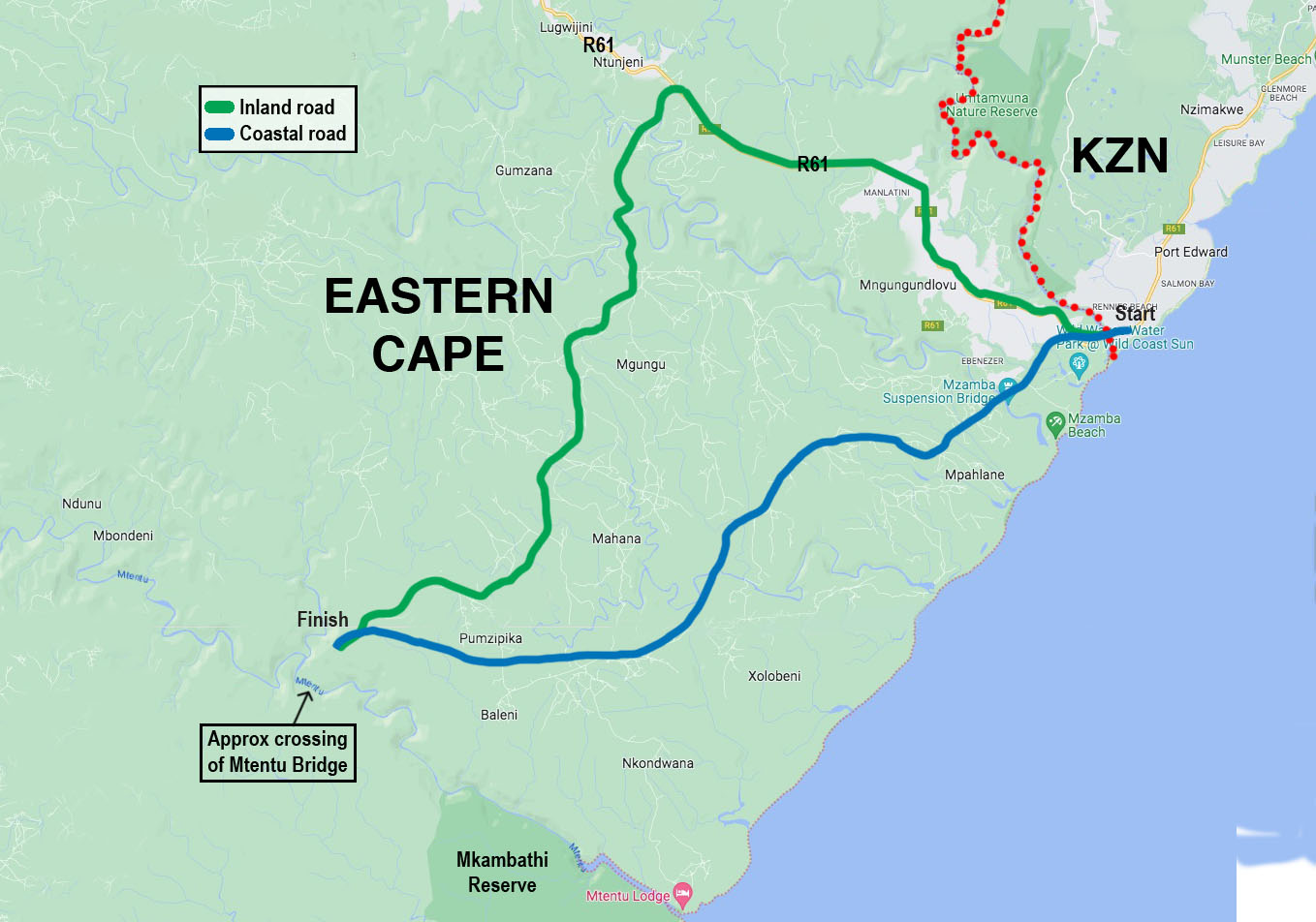
A comparison of the proposed alternative inland route (top, green) between Port Edward and the Mtentu River bridge and Sanral’s controversial route closer to the coastline (bottom, blue). (Map: Sheena Carnie)
The technical team appointed by the ACC includes a group of consulting engineers, urban development planner Malcolm Campbell, land governance specialist Dr Siyabu Manona, town and regional planner Johan Jonas, attorneys Wilmien Wicomb and Henk Smith, economics researcher Dr Dick Forslund and ACC spokesperson Nonhle Mbuthuma.
On 3 March 2023, members of the ACC technical team met Sanral officials in Gqeberha and discussed realigning the Xolobeni route to pass further inland via Lurholweni township on the R61.
But according to Forslund, Sanral has failed to respond to subsequent communication from ACC members and appears to have pulled out of further discussions.
Jonas told the seminar that, from an environmental perspective, the alternative inland route was a far better option than Sanral’s preferred coastal route, which passes through several “critical biodiversity” areas.
Manona suggested that economic growth at a national level had to be balanced against the environmental and social justice impacts at a local level.
Whereas engineers appeared to be hellbent on designing high-speed roads regardless of the social consequences, local communities could say “bye-bye to ecotourism” the closer the road came to the coast, while existing settlements further inland would also be bypassed by the new, faster coastal route.
Ribbon development
Manona further cautioned that the new route would trigger a spate of uncontrolled “ribbon development” along the sides of the new N2, while the demand for building sand would lead to major erosion and degradation of some of the country’s most pristine river estuaries and the fish life that supports local communities.
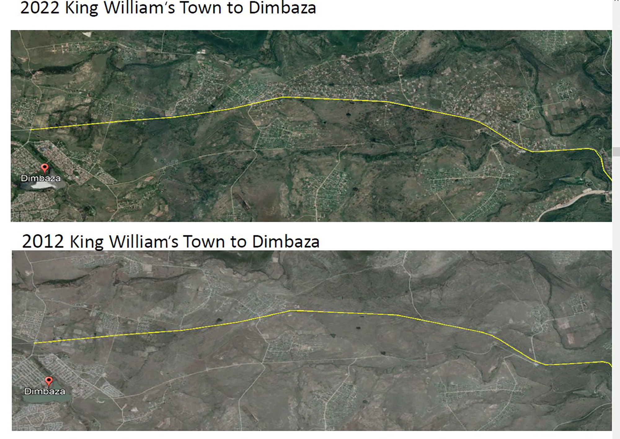
Two aerial views from 2012 and 2022 showing the recent ribbon development of new homes along the N2 between Dimbaza and King William’s Town (Qonce). (Image: ACC)
According to Jonas, there was abundant evidence that communities wanted to build houses as close as possible to major roads. But there was little evidence that municipal authorities in the Eastern Cape had the capacity or political will to implement adequate urban planning control measures.
Pointing to the steady increase of homes immediately adjacent to the N2 between Dimbaza and King William’s Town (Qonce), Jonas said: “We see no reason to believe that poor development control will be any different along the new Wild Coast toll road.”

Newly built homes along the N2 freeway between Dimbaza and King William’s Town (Qonce) in the Eastern Cape. (Image: ACC)
Jonas said there was already evidence that wealthy local stakeholders were positioning themselves to acquire new development sites for petrol stations, shops, hotels or tourism accommodation adjacent to the coastal toll route.
Forslund suggests that the Sanral coastal route is 32km long, compared with the 45km long inland route favoured by the ACC.
He calculates that the inland route adds an extra 10 minutes and 45 seconds to the travel time between the two cities (provided there are no additional delays such as stray cattle crossing the road).
Forslund further challenges the financial assumptions of the original Sanral tolling proposals as outdated and “dangerously optimistic”.
“We know that people in Gauteng don’t want to pay tolls,” he said, predicting that toll fees on the new N2 Wild Coast route would now be much higher than originally projected.
Forslund says one of his major concerns is the likely mushrooming of uncontrolled development along the Amadiba coastline if the current route alignment is not changed.
“People are already arriving here like hungry lions to grab land for development. If the N2 goes ahead in its current form, it will make what is already happening look like a picnic. These are not poor people, but rich people with political connections,” he claims. DM
Footnote:
Sanral was first approached for comment on 15 June. After the article was published on 26 June, a spokesperson for Sanral provided the following comments:
“A further inland route was found not to be feasible, as it would require either one additional mega bridge (700+m span) or two additional major bridges (2x 500+m) to cross the Ntlakwe and/or Mzamba gorges, but most importantly it would require the relocation of several hundred families in the densely populated villages between the Mzamba and Mtamvuna rivers. The Department of Environmental Affairs (DEA) had approved the planned route and Sanral was not authorised to move the road outside of the approved corridor. If a new EIA had to be undertaken it would not only delay the project by potentially several years, but the further inland route was again unlikely to be approved based on environmental considerations as well as social and economic reasons.
“The authorisation of the current route granted by the DEA in 2010 followed an extensive public participation process which included studying various possible alternative alignments for feasibility and that, on a balance of social, economic and environmental factors, the route ultimately approved by DEA was found to be the best route from the very limited set of routes found to be feasible.”
To read all about Daily Maverick’s recent The Gathering: Earth Edition, click here.













 Become an Insider
Nothing new it just goes to show and confirm how little this government cares about rural communities. Come elections you can bet your bottom dollar that they will be there waxing lyrical about having freed the people from subjection whilst making promises and buying votes. This time round the voters however are considerably more awake to their mendacious ways and hopefully that will reflect on the outcomes.
The Amadiba Crisis Committee (ACC) DO NOT represent the views of the Amadiba people and have no legal or moral mandate to claim to speak on their behalf! Not even a single solitary village has given them such a mandate. The ACC is a vocal local stakeholder and has legitimate views and opinions but represent no more than 5-10% of the Amadiba community. Equally the pro-mining lobby represent no more than 5% of the same community. The actual views of the Amdiba community are complex and nuanced, but the majority definitely do not see themselves as the anti-development ‘noble savages’ they are portrayed or seen as by the ACC and naive, albeit well meaning, reporters and supporters of the ACC. In my long and personal first hand experience working in the area and alongside them the Amapondo people and particularly the Amadiba community all desperately want development through the N2 Wild Coast road project and are overwhelmingly frustrated and tired of the continual delaying and frustrating tactics adopted by the ACC and their supporters
In 2018 the ACC tried to convince a High Court judge that SANRAL and Environmental Affairs had failed to adequately consult the Amadiba community and failed to consider alternative inland routes, but the judge found overwhelmingly against them. They did not appealed the case to the SCA, seemingly to avoid a high profile embarrassing failure. Instead they continue the case in the court of public opinion where facts and evidence are not required
From first hand professional knowledge I can unequivocally state that the proposed alternative inland route put forward by the Amadiba Crisis Committee (ACC) is simply not feasible for a class 1 National Road, requiring major compromises on maximum grades but most importantly the safety and well-being of the Amadiba communities living in the Lurholweni township that runs along the current R61 for 11 km North of the Wild Coast Sun. To overcome these design and moral deficiencies would require unacceptably enormous relocations and social disruption as well as two more mega bridges. The inland route also affects far more wetlands than the authorised route. The enormously comprehensive independent EIA which approved the current route as the best alternative on a balance of environmental, social and economic factors considered and rejected an almost identical alternative as non-feasible. The ACC did not put forward any realistically feasible alternative.
Their claim that the authorised route would compromise eco-tourism in the Amadiba area is not supported by evidence and is simply an emotional catch. In my own informed opinion the approved route will benefit the local Amadiba eco-tourism industry through vastly improved access for tourists. Similarly the claim that the N2 will divide communities from each other and their lands is demonstrably false with improved local roads and frequent under/over passes included in the designs workshoped with the affected communities.