


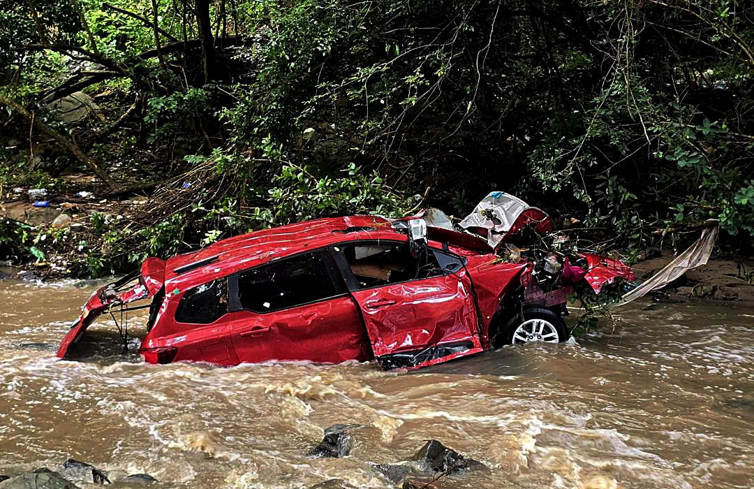
 A vehicle that was washed off a low-level bridge in Amanzimtoti, south of Durban, on 21 December 2025. South Africa can expect above-normal rainfall and cooler temperatures through early 2026, lowering temperatures but increasing the risk of localised flooding. (Photo: Supplied: ALS paramedics)
 If it feels as if the sun has taken a holiday too and the days feel less hot than usual, you’re not imagining it. The past two months have shaped up to be wetter and slightly cooler across much of South Africa, particularly in the interior. This has resulted in flooding in parts of KwaZulu-Natal and the Eastern Cape, in addition to golf-ball-sized hail in much of Gauteng, Mpumalanga and Limpopo.
At least four people died due to flooding in KwaZulu-Natal last week, while more than 100 houses were damaged in the province due to severe weather over the weekend. In Gauteng last week, one person reportedly died in Olievenhoutbosch following heavy rainfall.
Read more: Severe weather: Death toll rises to 5 as relief operations across SA kick into gear
Of course, the picture has been much different in the Western and Northern Cape and the southwestern parts of the Eastern Cape, where temperatures have been a bit more toasty and the skies drier.
South Africans should brace for more of this, at least for the next few months, as these trends are expected to continue into 2026.
According to the South African Weather Service (Saws), climate models are pointing to weak La Niña to El Niño-Southern Oscillation-neutral conditions persisting through the core of summer.
In plain terms, this tips the odds towards increased above-normal rain and fewer days of extreme heat in Gauteng, Limpopo, Mpumalanga, KwaZulu-Natal and parts of North West and the Free State.
Michelle du Plessis, a meteorologist with Vox Weather, cautioned that the forecast was one that “tilts the odds” rather than promises outcomes, a crucial distinction echoed by Professor Willem Landman, a climate scientist at the University of Pretoria, who warns against treating seasonal forecasts like day-to-day predictions.
/file/attachments/orphans/G8tzqWuXwAAM2Qc_519580.jpeg "A road at Manaba beach in Margate in southern KwaZulu-Natal following heavy rain in December 2025. <br>(Photo: Traffic 24 KZN / X)<br>")
(Photo: Traffic 24 KZN / X)
Why La Niña (even a weak one) matters
The tropical Pacific Ocean is experiencing what Landman described as a very weak La Niña, a climate pattern where the ocean water becomes cooler than normal, although it is already starting to fade towards neutral conditions.
This matters because La Niña years are associated with wetter summers and cooler daytime temperatures over South Africa’s interior provinces.
However, it doesn’t mean rain everywhere, all the time. It means the probability of wetter conditions is higher than average, especially between January and March 2026.
During the Saws briefing, climate scientist Kobus Olivier said La Niña was expected to last only two months and that weather conditions should normalise by February 2026.
“The important thing is that we are not heading into El Niño this summer. There’s no indication of that. And without El Niño, there’s no strong drought signal on the table for early 2026,” Landman said.
Based on the Seasonal Forecast Worx outlook and Landman’s modelling insights, here’s how the first two months of 2026 are shaping up in the country:
Gauteng
Expect a continuation of frequent summer rainfall, with an increased likelihood of afternoon thunderstorms through January and February.
Daytime maximum temperatures are likely to be slightly cooler than normal, especially during wetter spells – though humidity will remain high.
/file/attachments/orphans/ED_547184_955440.jpg "Gloomy clouds loom over Johannesburg in Gauteng, South Africa. (Photo: Gallo Images / OJ Koloti)")
Limpopo and Mpumalanga
These provinces sit firmly in the zone of enhanced rainfall probability. Landman’s models show no drought signal here, and the risk leans towards above-normal rainfall. This is good news for agriculture, but it raises concerns about localised flooding.
North West and the Free State
Rainfall odds also lean towards wet conditions, particularly in the central and eastern parts of both provinces. Western areas may be more variable.
Cooler-than-average daytime highs are possible during peak rainfall periods, but heat spikes are still likely between rain events.
KwaZulu-Natal
KwaZulu-Natal is expected to see above-normal rainfall, especially along the coast and in the Midlands. Warm, humid conditions will dominate, with flood risk elevated during intense rainfall episodes – something municipalities will need to monitor closely.
Eastern Cape
This province is a tale of two climates. The eastern interior aligns more closely with the summer rainfall regions and could see wetter conditions, whereas the southwestern parts remain more uncertain, influenced by shifting weather systems rather than tropical drivers.
Western Cape
Summer forecasts in this region are far less reliable, but models suggest a higher likelihood of drier-than-normal conditions over the southwestern Cape during summer, along with warmer-than-normal temperatures, particularly along the coast.
Conversely, beachgoers in the Western Cape will have a much more enjoyable experience with spells of above-normal heat expected, but senior Saws forecaster Jackie Modika warned that they should be aware that warmer temperatures bring the possibility of heatstroke.
Landman cautioned that unlike the interior, the seasonal predictability was weakest in Mediterranean climates such as the Western Cape.
“We’re very good at forecasting cold fronts a few days ahead, but seasonal signals here are much harder to pin down,” he said.
/file/dailymaverick/wp-content/uploads/2025/03/12904979.jpg "Tourists enjoy the late afternoon sun as they visit Camps Bay beach in Cape Town, South Africa. (Photo: EPA-EFE / Kim Ludbrook)")
Global warming
One of the paradoxes of wetter summers is that they often feel cooler, even as long-term temperatures continue to rise.
November, for example, was notably cool in many parts of the country, largely because of persistent cloud cover and rain.
However, this does not mean that the world is not warming. Landman noted that over the past few years we have seen average temperatures increase consistently. The year 2024 was the hottest year on record, with global average temperatures breaching the 1.5°C warming threshold for the first time.
“If you look over decades, temperatures are clearly rising. But you can’t judge climate trends by a few wet weeks,” Landman said.
Although the rain may be good for dam levels and agriculture, it doesn’t mean less risk. In fact, above-normal rainfall increases the chances of flash flooding, especially in urban areas with poor drainage and informal settlements that are located in flood-prone zones.
Looking ahead to later in 2026
Beyond autumn, the models show less confidence. There are early signs of warming in the central Pacific later in 2026, which could nudge conditions towards a weak El Niño. If that happens, it would typically favour drier and warmer conditions over parts of northern and eastern South Africa.
But both Du Plessis and Landman stressed that it was far too early to bank on that outcome.
“Seasonal forecasts are not promises,” Landman said. “They’re tools. They tell us what’s more likely, not what will happen.”
The bottom line
For the rest of 2025 and the first few months of 2026, South Africans should prepare for:
- A wetter-than-normal bias across most summer-rainfall provinces.
- Fewer days of extreme heat, but conditions will be sticky and humid.
- Increased flood risk, especially during intense storms.
- Continued uncertainty, particularly outside the summer-rainfall regions.
And perhaps most important: keep checking the short-term forecasts. Seasonal outlooks set the scene, but the day-to-day weather forecasts still serve as a risk mitigation tool. DM
This story first appeared in our weekly DM168 newspaper, available countrywide for R35.
/file/attachments/2986/DM-19122025-001_613320_d2f06eb566b3d566ff7615022a5c63b9.jpg)