


 August saw quite a few all-time temperature records broken along the West Coast, particularly on Monday and Tuesday this week, according to the South African Weather Service. (Photo:Gallo Images / Die Burger / Jaco Marais)
 It’s been a cold and ruthless winter – but for a few days this week in the Western Cape, you would never have guessed it with the region experiencing scorching hot weather conditions and record-breaking maximum temperatures, some parts even exceeding 34°C on Tuesday, 29 August (still officially winter).
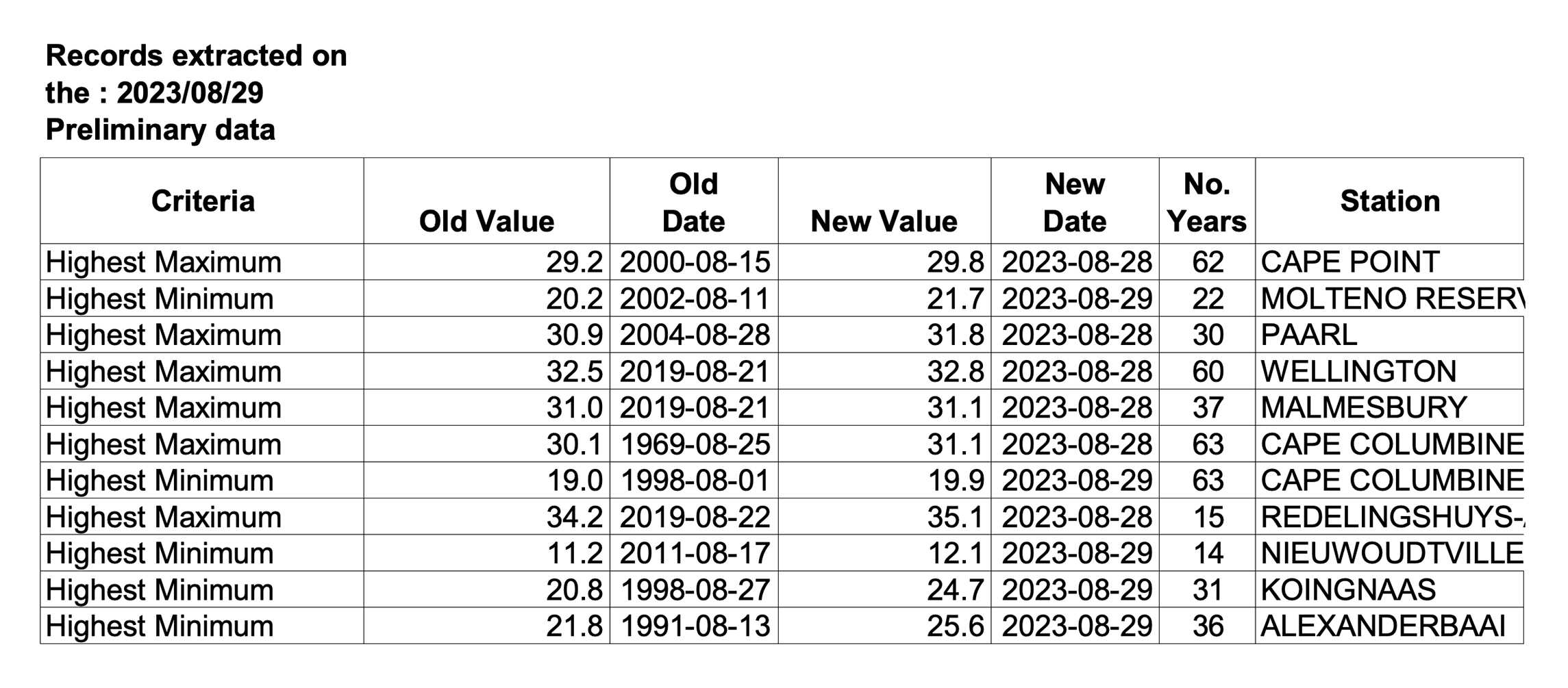
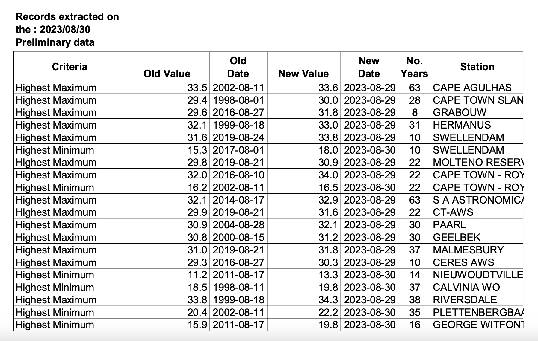
Particularly warm areas were Paarl, Cape Town, Malmesbury and Alexander Bay, where a slight heatwave was recorded. On Tuesday, in Cape Town, where a maximum temperature of 34°C was registered, beaches were brimming with people seeking relief from the unbearably hot weather.
According to the Climate Shift Index (CSI), reaching this temperature was five times more likely because of climate change. The CSI is a relatively new tool by Climate Central that shows just how much climate change may be affecting our local weather on any given day.
According to the South African Weather Service, these record-breaking temperatures were the result of strong offshore (northerly to northeasterly winds) conditions along the west coast of South Africa associated with a surface trough off the western part of the country and a dominating high pressure over central South Africa.
Stefaan Conradie, a PhD student in climatology from the Climate Systems Analysis Group at the University of Cape Town (UCT), added that the weather phenomena involved were typical of a berg wind (or “ooswind” as they call it in Namaqualand), weather along the west and south coast, with a high pressure along the east coast, an approaching cold front in the Atlantic and surface low along the west coast.
“This sucks warm dry air south and west. Such conditions are relatively common between April and October, but the high pressure has been ‘stuck’ in position for a few days, which is a less common occurrence and has led to warm temperatures persisting and building up over a few days,” he said.
The South African Weather Service issued an advisory for heatwave conditions over Alexander Bay from Sunday until Tuesday this week. These temperatures can occur especially ahead of a cold frontal system, which is expected to hit the Western Cape on Thursday, 31 August.
The definition of a heatwave requires three consecutive days with maximum temperatures (meeting or exceeding) 5°C greater than the average maximum of the hottest month for a particular station. This criterion was met in Alexander Bay only.
The South African Weather Service said that, on average, August has been close to normal so far but there have been a couple of significantly warm days during the month. This warm weather is expected to continue throughout summer and spring, according to the weather service’s latest seasonal watch for September to January.
The seasonal climate watch indicates above-normal maximum temperatures for spring and early summer, and the weather service has warned that both minimum and maximum temperatures are expected to be mostly above normal countrywide for the forecast period.
Impact of El Niño still uncertain in South Africa
The El Niño-Southern Oscillation is currently in an El Niño state and, according to the latest predictions by the South African Weather Service, is expected to persist through most of summer. The effects of this remain unknown, with current global forecasts indicating a great deal of uncertainty for the typical drier conditions that South Africa experiences during an El Niño.
The multimodel rainfall forecast indicates above-normal rainfall for most of the country in mid-spring (September–November) and late spring (October–December). Early summer (November–January), however, indicates below-normal rainfall over the central parts of the country and above-normal rainfall for the northeast.
Cobus Olivier, seasonal forecaster at the South African Weather Service, explained that during an El Niño season, seasonal predictions tend to be more accurate than normal over the summer rainfall areas (northeast of South Africa), but the predictions at the moment are mixed and currently forecast something quite different from what they would normally expect.
This could just indicate that the El Niño effect has not yet strengthened sufficiently to have an influence, but this can change in the coming months.
“We are expecting to go into a strong El Niño for the summer season this year,” Olivier said.
Read more on Daily Maverick: Here comes El Niño – and experts warn South Africa to ‘be prepared for the worst’
There has already been significant rainfall over Cape Town recently, with early winter rains being above average.
Conradie said that as of Monday this week, the “big six” dams in the Western Cape Water Supply System supplying Cape Town were all at least 100% for the first time since 2021. The total Western Cape Water Supply System dam storage is now at 103.3%.
The peaking full moon spring tide
Residents across the Western Cape and other regions in southwestern parts of the country can expect much cooler conditions for the rest of the week and weekend ahead. On Thursday, 31 August, residents should be prepared for scattered to isolated rain followed by fine and warm to cool conditions.
Meanwhile, the National Sea Rescue Institute (NSRI) warned the public to be particularly cautious around the country’s coastline as the spring tide will peak during the super blue moon on Wednesday, 30 August, and Thursday, 31 August.
The spring tide occurs at the full moon and new moon every month, causing the high tide to be higher than normal and the low tide to be lower than normal, which can increase the strength of rip currents. However, because it is a super moon – when the moon is closer than usual to Earth – the moon’s gravitational pull will be stronger and the tides are expected to be higher. The spring tide should begin to wane from Friday. It is called a blue moon when the full moon appears twice in one month.
“Together with winter rough sea conditions that are prevailing around our coastline with cold fronts that have passed in recent days and weeks, and with storms prevailing in deep sea off the South African coastline, the NSRI is appealing to the public around our coastline to be cautious during this spring tide.” DM