
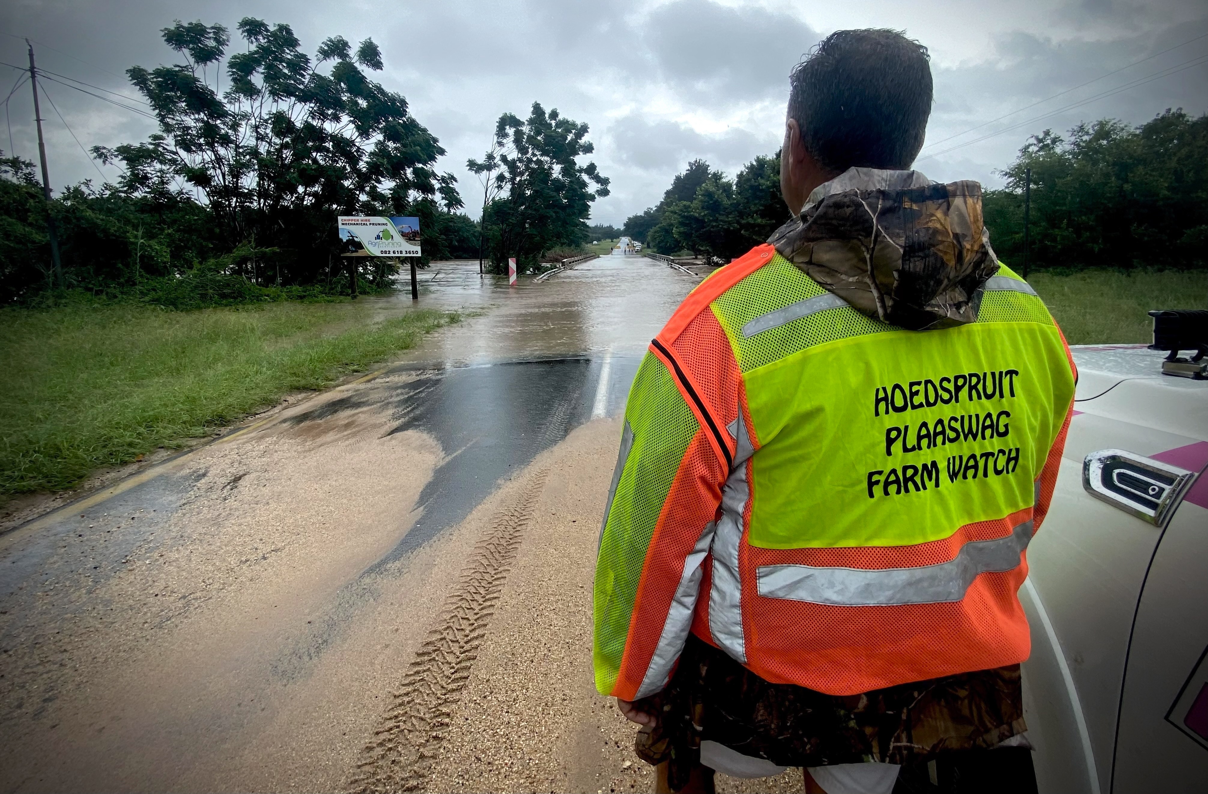
 A security member of Hoedspruit Farm Watch observes the Zandspruit River overflowing onto the Zandspruit Bridge on the R527 leading out of Hoedspruit, Limpopo, on 13 January. (Photo: Tiara Walters)
 As a storm from Mozambique continued to drench parts of Limpopo and Mpumalanga this week, pilots, conservation workers and residents in and around Hoedspruit, Limpopo, were watching river levels like hawks. Locals here do not need the memory of an elephant to recall the devastating 2012 floods, when lodges were submerged and tourists and residents were ferried out by boat and helicopter.
Gerry McDonald, a helicopter pilot with Big Game Heli Services in Hoedspruit, evacuated tourists on Tuesday and was planning more evacuations on Wednesday. The company specialises in conservation, anti-poaching support and wildlife operations.
“It’s very similar, you know, that long sort of gentle, soaking rain — in 2012 it was exactly the same,” McDonald told Daily Maverick. He was preparing for any eventuality. “The rivers are rising and the predictions anticipate more rains.”
On Tuesday, the Sabi Sand Nature Reserve manager, Riaan Kruger, said the enclave of iconic private reserves on Kruger National Park’s southwestern border was open and operating. Although larger service trucks were not accessing Sabi Sand, guests were being transported in 4x4 vehicles during the wet conditions.
“Obviously, 2012 was pretty big, and we all remember the January 2000 floods,” cautioned Kruger, recalling the catastrophic effects of Cyclone Leon-Eline from Mozambique, which inundated northeastern South Africa, killing about 800 people. “I don’t think the current situation is anywhere close. Yes, the Sand River is in flood and day-to-day logistics are more difficult, but there’s no state of emergency in the reserve.”
Sabi Sand had received 150mm of rain from Sunday to Tuesday. “There’s still some rain forecast for the next few days,” Kruger underlined.
/file/attachments/orphans/ZandspruitRiver_400341.jpg "Water overflowing onto the Zandspruit Bridge on the R527 leading out of Hoedspruit, Limpopo, on 13 January. (Photo: Tiara Walters)")
Roads cut, lodges isolated
McDonald said he had received calls asking him to assist with air evacuations as several private reserves and lodges in the greater Kruger region had been temporarily cut off by rising rivers or risked being isolated.
Traffic authorities had closed the R527 Zandspruit Bridge leading out of the small town, which does not have any traffic lights, “due to flooding”. When Daily Maverick inspected the Zandspruit River on Tuesday at 2.30pm, it was overflowing on to both sides of the R527. The bridge was completely submerged in brown, soupy water.
Dr Ben Muller, a veterinarian with Wildscapes Veterinary and Conservation Services, confirmed that river crossings had been disrupted.
“You can’t cross the Klaserie River,” he said, citing conditions reported from private reserves. “People are stuck.”
People on estates near the Blyde River, which had reportedly burst its banks, were unable to reach central Hoedspruit, where supermarkets were still trading, but many businesses were closed.
Ghosts of 2012: Damning dam conclusions
McDonald pointed to the role dams had played in past disasters. In 2012, the pilot said, “The rivers came up in flood and then the dams broke. So, once those dams started breaking, there was devastation below.”
After those floods, the dam infrastructure in Klaserie along the eastern central Kruger region was not rebuilt. “There’s a lot more free-flowing water now,” said McDonald. “That was a big problem — those dams broke and this big wall of water came pouring down.”
In the past week, a particularly wet few days had soaked the ground, increasing run-off. “The ground is actually saturated,” McDonald observed. The region had already received significant rains this season when the storm from Mozambique started rolling in over the weekend. “Any water that comes from the rain now, it just runs off. So, anything flooding is going to be because of that.”
He said the South African Weather Service (Saws) was still regarded as a reliable reference point, even as international weather apps fluctuated sharply from update to update. “But I like to compare all of them.”
Wildlife expected to cope
Regardless of concerns about the impact on wildlife, McDonald was unequivocal. “No, no, no — it won’t affect the wildlife at all. They can move freely. The areas are really big. They can always get onto high ground. That was also the case in 2012.”
Muller, the veterinarian, echoed his focus on preparedness rather than overreaction, saying conservation teams and reserve managers were monitoring conditions and planning contingencies, particularly for animals kept in camps.
The Moholoholo Wildlife Rehabilitation Centre outside Hoedspruit said it had not received reports of injured animals nor had it taken in animals hurt by rain or flooding.
Sabi Sand said none of the reserve’s wildlife had been in “sticky” situations. “The buffalo and rhino are just loving the pools forming throughout the reserve,” said Kruger.
Disruption, not all-out disaster — for now
The picture emerging in reserves and the broader conservation industry in northeastern South Africa this week has, so far, been one of severely testing conditions and isolation rather than all-out devastation: flooded causeways, detours, stranded vehicles and temporary evacuations by helicopter have been common.
On Monday, a South African National Parks (SANParks) advisory said some roads and gates in Kruger National Park had been closed.
In northern sections of the park, gates at Pafuri and Punda Maria were inaccessible, “meaning the only access to the northern region of the park is via Phalaborwa Gate”. In the south of the park, Crocodile Bridge was being monitored while some roads were also shut.
“SANParks is actively contacting all guests with imminent arrivals to Kruger National Park to reschedule their visits,” the advisory said.
Eastgate Airport, the main air hub serving the safari capital, was closed for business on Tuesday “due to weather”, an airport spokesperson told Daily Maverick.
Outlook for Wednesday
In the 24 hours to 8am, Tuesday, alone, some Saws stations in the greater Kruger region had tracked more than 150mm of rain. The Tshakhuma station to the west of northern Kruger had recorded 176mm. Kruger-Mpumalanga International Airport in greater Kruger’s southern reaches had clocked far less at 18mm.
Saws issued Orange Level 9 warnings for eastern Limpopo and the Mpumalanga Lowveld and escarpment on Wednesday. Orange Level 6 was expected over central Limpopo. A Level 9 warning signals a high risk to life with widespread flooding and damage, while Level 6 indicates serious but more localised impacts.
Saws spokesperson Hannelee Doubell told Daily Maverick those warnings remained in place due to disruptive rain.
Significant impacts were likely due to saturated soil, said Saws.
Hoedspruit citrus farmer Braam van der Merwe pointed out that he had experienced limited disruptions. However, farms in Tzaneen, further northwest, had received more than 100mm of rain on Monday into Tuesday, according to Saws readings.
One thing is certain. Situated in a summer rainfall region, the famously hot provinces of Limpopo and Mpumalanga are now positively bursting with life and vast, iridescent tracts of rolling green bushveld. It is stunning. The wild card is when the rain will end.
“Ons is dankbaar vir die reën, maar dit moet nou stop. [We are grateful for the rain, but now it must stop,]” Van der Merwe observed. DM