


 What might South Africa’s future climate might look like? In the third and final part of our climate data series, we look at how different places compare when it comes to healthcare in the face of extreme weather. (Juan Moccagatta / For Pexels)
 Things could be hot during the Fifa World Cup, which kicked off with Mexico and South Africa on 11 June.
But likely not only because of the sporting action.
This year’s tournament will be spread over 16 cities across Mexico, the US and Canada, and analyses predict that many of the matches in the southern parts of the North American continent are likely to be played in uncomfortably hot conditions.
It’s in line with global weather models having forecast above-normal temperatures for April to June in the southern and central parts of the northern hemisphere – and offers a glimpse into how changing climate conditions are becoming a normal part of people’s lives.
The world has seen the 11 hottest years on record between 2015 and 2025, the World Meteorological Organisation’s latest State of the Global Climate report shows. Moreover, the average temperature for 2024 was officially the highest in more than 175 years since people started keeping track – and the first time it went 1.5°C above pre-industrial levels.
The planet’s near-surface air temperature breaching the “1.5°C above” barrier once doesn’t mean the Paris Agreement’s goal of keeping global warming in check by the end of the century is unattainable. But seeing it along with the trend of the past decade sends a stark warning of the level of warming that might lie ahead if we don’t seriously cut down on carbon emissions.
When Earth’s atmosphere is warmer than what it’s naturally supposed to be – as has been happening over roughly the past 100 years – global weather patterns are upset, which climate experts agree is likely to lead to intense and unpredictable extreme weather events occurring more often than before.
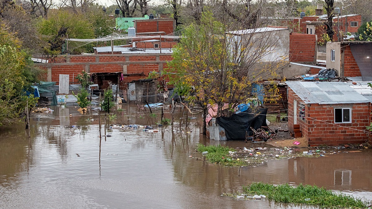
Analyses suggest that this is already the case. For example, a rapid attribution study – which looks for cause-and-effect relationships in the aftermath of an event – shows that the heavy rainfall that led to destructive floods in southern Mozambique and the far north of South Africa in January would have been very rare in a world without human-caused global warming at the levels we’re seeing today.
With more and more findings like this when it comes to heavy storms, excessive rainfall, droughts, heatwaves and wildfires seen over the past few years, it’s not surprising that decision-makers across the world rank extreme weather as the biggest threat facing humanity in the next 10 years.
In the second instalment of our three-part series on what South Africa’s climate future might look like, we showed that weather patterns could change in different ways across the country’s five climate zones in a warming world. But what does this mean for people’s lives – and plans to stay well – when heavy weather hits?
This was the question we wanted to unpack in today’s story. So we dived into census data to get an idea of how the way people live could add pressure to systems for keeping healthy and safe, and put together a summary graphic for each of the five climate regions in the country.
It’s a thought experiment for which we made a number of assumptions to get a sense of how health service delivery could be affected. For example, we used the District Health Barometer of 2022/23 to count the number of public health facilities in the districts that make up a specific climate zone (we counted a total of 3,811 across the country) and looked at the most recent census data (2022) to get population figures and sizes of areas to do our sums. We realise that people also have access to private health facilities, but seeing that 85% of the population rely on public healthcare, we reasoned that it’s a fair starting point for our experiment.
We also looked at what the census data said about where people live and what their houses look like, and whether they have access to sanitation services like flush toilets and piped water. We realise that our analysis might be a very simple way of looking at things, but we just wanted a departure point for comparing regions that will likely have to deal with different pressures.
To refresh your memory of how climate zones and provinces link, keep this map in mind:
/file/attachments/orphans/Graphic1SouthAfricahasfiveclimatezones_719383.jpg)
- Region 1 is the far north of the country, and covers all of Limpopo and small parts of North West and Mpumalanga.
- Region 2 spans the eastern interior and coast, covering the provinces of Gauteng and KwaZulu-Natal in full, most of Mpumalanga, and large parts of the Eastern Cape, the Free State and North West.
- Region 3 is the central interior of South Africa, covering the western part of the Free State, North West and the Eastern Cape, and the bordering part of the Northern Cape.
- Region 4 covers the northern and western parts of the Northern Cape.
- Region 5 spans the Western Cape and southern part of the Northern Cape.
Region 1: The hot summer-rainfall area in the northern parts of South Africa
Climate region 1 in the far north of South Africa is home to about 14% of the country’s population, with most people living in rural areas where land is shared and communities are generally governed by a traditional leader.
/file/attachments/orphans/Region1_424942.jpg)
Almost 20% of the country’s public health facilities are found in this region, serving, on average, close to 12,000 people each, our analysis showed. (We realise, though, that in practice health facilities might not be evenly spread across an area, but it’s a starting point in our thought experiment.)
The data further shows that there’s a clinic or hospital in roughly every 220km2. (If a health facility were in the middle of a circle of this size, it would mean someone would have to travel close to 8.4km from any point along the outside rim – and that’s if the road is a perfectly straight line.)
However, seeing that roughly eight out of 10 people live in traditional areas and about two-thirds of roads in this region have a gravel surface – most of which are in a poor state – it’s possible that getting healthcare could be difficult when extreme weather hits, like in January when heavy floods washed away many roads, bridges and clinics.
Region 2: The eastern part of South Africa, with all-year rainfall and mild temperatures
Two-thirds of South Africa’s population live in climate region 2, with most in urban areas. Just more than 60% of the country’s public health facilities are here, serving roughly 16,000 people each if we divide the population by the clinic and hospital counts. And, looking only at the numbers, it would seem that healthcare should be fairly accessible, with a facility being available in every 160km2. (If a health facility were in the middle of a circle of this size, it would mean the shortest distance someone would have to travel is 7.1km from any point on the rim.)
/file/attachments/orphans/Region2_228009.jpg)
But in practice this might not play out.
While region two as a climate zone is considered to have all year round rainfall, some areas within it, like the highveld, predominantly receive most of their precipitation over the summer months.
Analyses show that this part of the country is often hit by heavy rain and storms, which are likely to occur more often in the future and become more unpredictable. On top of this, about one in seven people in this region live in informal houses and more than two-thirds are in urban areas, two things researchers say can be dangerous when extreme weather such as floods or storms hit.
For example, in unplanned and densely populated areas, drainage systems can easily be overwhelmed during heavy downpours and when people live in makeshift houses they generally have little buffer to protect themselves or rebuild their homes when disaster strikes. In fact, modelling shows that most of the settlements that are prone to the fallout of flooding are in climate region 2.
But it’s not only people in urban areas who could be affected. Slightly more than a quarter of people in climate region 2 live in traditional rural areas, where roads may become inaccessible during floods and storms. For example, 90% of roads in the Eastern Cape are unpaved, which the province’s health department said in an inquiry by the Human Rights Commission in 2023 makes it difficult to care for people, especially during extreme weather.
Region 3: The central interior of South Africa, with hot days and summer rainfall
Climate region 3 spans about a quarter of South Africa’s land area, but is home to only 7% of the population. Seven out of 10 people live in urban areas, while a quarter live in traditional areas and the rest on farms.
/file/attachments/orphans/Region3_613666.jpg)
A tenth of the country’s public health facilities are found in the municipalities that make up climate region 3. The fairly low population density suggests that, in theory, clinics and hospitals should be able to serve people easily, with one facility for slightly fewer than every 10,000 people, our numbers show.
But it might be hard to get to a clinic or hospital, seeing that our sums showed that there is, on average, one facility in every 726km2. (If a health facility were in the middle of a circle of this size, it would mean the shortest distance someone would have to travel is just over 15km from any point on the rim.)
There’s more to consider than just densities and distances, though. For example, in 2024, a survey by the nonprofit HIV service monitoring programme Ritshidze showed that only 15% of the 72 facilities they visited in North West, which falls in this climate zone, had enough staff and that patients had to wait, on average, close to four hours to see a health worker. Only about half of the clinics had a working generator, which could mean bad news if a heavy storm knocks out electricity supply in an area.
But with this climate region stretching across parts of four provinces, how people prepare for weather disasters could be more complex still.
Analyses by climate scientists show that communities in districts along the border between North West, the Northern Cape and Free State may struggle to brace for extreme events, mostly because of high levels of social inequality and poverty. Further south, the parts of the Eastern Cape that fall in this region are expected to see more droughts and water scarcity as weather patterns change. This suggests to us that pressure on health services because of a changing climate in this region will likely not be fixed by a one-size-fits-all response.
Region 4: The western part of South Africa, with hot, desert-like conditions
Less than 1% of South Africa’s population live in this region although it covers about 13% of the surface area, possibly because of life generally being hot, dry and harsh here. About 2% of the country’s public health facilities are found here and, given the low population density, the numbers suggest that service pressure on clinics and hospitals would be the lowest of all regions.
However, taking into account how big this area is, it becomes clear that getting help might be far more difficult, seeing that, on average, there’s one facility in an area of about 2,600km2. (If a health facility were in the middle of a circle of this size, it would mean the shortest distance someone would have to travel if they were on the outside rim is about 28.7km.)
/file/attachments/orphans/Region4_972833.jpg)
In this region, about half the population live in urban areas and half on farms, with about one in six not having a formal house and just under 10% not having a flush toilet. Almost all households have access to piped water, though.
Climate models predict that rainfall could not only become unpredictable in this area but also drop by 20% to 40%, which, given that municipalities here rely almost entirely on groundwater, could mean that it would be hard to buffer a drought. Without enough water, people, crops and livestock will struggle to survive, and in an area where almost half the population live on farms, changing weather patterns could have dire consequences for people’s livelihoods.
This can have a knock-on effect on people’s health. For example, a modelling study showed that a bad drought could make HIV spread – not because the virus becomes more infectious, but because people’s behaviour changes when their livelihoods are threatened. For example, mental worry can make it hard for people on daily, chronic medication to take their treatment regularly. Or when floods or droughts strip people of their income, it creates a market for transactional sex, which lowers women’s ability to negotiate for safe sex, and so increases rates of HIV infection.
The Northern Cape, where this climate region is found, has some of the lowest levels of HIV in South Africa. However, findings from the latest prevalence survey by the Human Sciences Research Council show that 21,000 more people had become infected by 2022 than by 2017. This might not seem like a big change, but given the small population in the Northern Cape (and by implication also this climate region) it’s a worrying jump, researchers say.
Region 5: The southwestern part of South Africa, with a Mediterranean climate and wet winters
This climate region covers the whole of the Western Cape, extending into the southern parts of the Northern Cape. About 12% of the country’s population live here, with 94% in urban areas. Just under 10% of South Africa’s public health facilities are found here.
/file/attachments/orphans/Region5_573757.jpg)
However, what surprised us was that, despite there likely being a clinic or hospital in every 669km2 area, a facility has to serve close to 20,000 people, according to our sums. (If a health facility were in the middle of a circle of this size, it would mean the shortest distance someone would have to travel is almost 14.6km from any point on the outside rim.)
If everyone were to use public healthcare here, it would be the highest level of service strain of all regions, surpassing what could be seen in climate region 2, where two-thirds of the country’s population live.
Most people in this Mediterranean climate region live in urban areas and one in seven have informal houses. Put together it can be hard for people to cope when heavy weather such as storms or floods hit.
But models show that this region could expect not only unpredictably heavy rainfall at times, but also bad droughts in some years – two extremes that could make it hard to put plans in place to keep people safe and healthy in the face of changing weather patterns. DM
Read the other two parts of the series here and here.
This story was produced by the Bhekisisa Centre for Health Journalism. Sign up for the newsletter.