


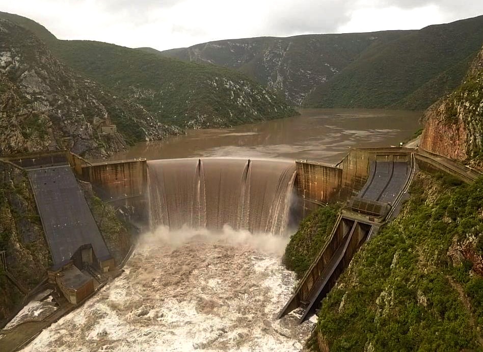
 The Kouga Dam rose from 32% of capacity to 110% in 24 hours. The last measurement stood at 119% as water spilled over the dam wall at 2.2-million litres per second. (Photo: Werner du Preez)
 Severe weather across the Eastern Cape and Southern Cape has driven the Kouga Dam into overflow, forcing evacuations along the Gamtoos River valley and placing widespread pressure on water infrastructure – 2.2-million litres of water poured over the Kouga Dam’s spillway every second when it reached 119.2% capacity on Thursday morning.
These figures are even more staggering if you take into account that 24 hours earlier, the dam was at only 32% capacity.
Parts of the Kouga Dam’s catchment area measured as much as 900mm of rain in 48 hours as heavy downpours and strong winds continued to batter parts of the country.
While there is a sigh of relief as a looming drought in Nelson Mandela Bay has been temporarily averted, the past week’s torrential rains have caused immeasurable damage in parts of the Eastern Cape, Western Cape and Garden Route.
In the Kouga Municipality, flood warnings and evacuation notices were circulated early on Thursday morning, and property owners on the banks of the Gamtoos River, downstream of the Kouga Dam, were forced to move livestock to higher ground and leave the area for their own safety.
In Patensie, one of the Eastern Cape’s citrus production hubs, entire orchards were inundated, leaving just the tops of some trees and structures sticking out above the rising water levels.
Meanwhile, Paradise Beach, near Jeffreys Bay, was cut off as the only low-water bridge granting access to the coastal village was waterlogged.
/file/attachments/orphans/KougaFloods1_515070.jpg "Residents of Paradise Beach in the Kouga Municipality were cut off as the only low-water bridge leading from Aston Bay was flooded. (Photo: Riaan Marais)")
“When we took the last measurement at the Kouga Dam, shortly after 11am on Thursday, the dam was at 119.2% capacity. Water was spilling over the edge at 2,249 cumec (2,249,000 litres per second),” said chief executive of Gamtoos Water Reinette Kolesky.
Gamtoos Water manages Kouga Dam operations, the largest dam in the water system supplying Nelson Mandela Bay.
She said further readings would have jeopardised the safety of staff at the dam, but they continued to monitor the water levels and the run-off from the catchment area still flowing into the Kouga Dam.
“To be honest, we are not sure how much water is still on the way. Some parts of the wider catchment area reported as much as 900mm of rain, and in other places, we were unable to get accurate rainfall figures as we lost signal to some of the measuring stations.
“At this stage, our top priority is to manage the dam and monitor the flow. We are in constant contact with the Department of Water and Sanitation, the Kouga Municipality and all the relevant emergency services to ensure the safety of the surrounding area.”
/file/attachments/orphans/KougaFloods3_715405.jpg "Farming equipment, such as this centre pivot that could not be moved, was left waterlogged as the Kouga Dam spilled over and flooded the Gamtoos River Valley. (Photo: Riaan Marais)")
Kolesky warned against false reports on the condition of the dam, as social media posts did the rounds saying that Kouga Dam was cracking or had broken.
She said safety margins at the dam allowed for a 6,100 cumec overflow – far beyond the present conditions.
On Wednesday morning, the Nelson Mandela Bay water system was at a combined 36.1% full across all its dams. By Thursday evening, the three main storage dams, Kouga, Churchill and Impofu, were overflowing.
At capacity, Kouga holds 125,000 megalitres of water, while Impofu and Churchill hold up to 105,000 and 35,000 megalitres respectively.
According to sources on the ground, it was the first time in 11 years that Impofu was over capacity.
In the Kouga Municipality, mayor Hattingh Bornman issued a warning on Thursday morning that emergency shelters would be established at community halls across the municipality for residents needing to evacuate their homes.
/file/attachments/orphans/KougaFloods4_639011.jpeg "Citrus farms on the outskirts of Patensie, in the Kouga Municipality, were inundated. While some orchards were completely submerged, trees and structures barely protruded above the rising water levels. (Photo: Johan van der Watt)")
Major areas of concern were farms along the banks of the Kouga, Groot and Gamtoos Rivers, as well as camping grounds, hotels and resorts downstream of the Kouga Dam.
At the Gamtoos Ferry Hotel, owner Roy Herselman had evacuated his staff and was already in contact with his insurance company about risks to the property.
“There is little we can do at this stage. We closed the hotel, sent staff home and we are waiting for trucks to move some of the movable assets. Other than that, we can only wait and see.”
His neighbour on the river banks, Pienaar Vivier, had moved as much of his furniture, electronics, clothes and other valuables to the top floor of his holiday home.
“We’ve moved what we can, and now we hope for the best. My neighbours have offered to house some of my vehicles while we go home to our farm in the Northern Cape. Once the water has subsided, we’ll come back and check what the damage is.”
Further upstream, a farm manager could do little but watch the water levels rise to engulf the pastures where his boss’s cattle normally graze.
“From the fence to the edge of the river is about 400 metres, and all of that is now underwater. Luckily, we moved the cattle in time.
“However, the fruit and veg farmers further up the river were not so lucky. They are going to lose a lot, if not all, of their harvest.”
/file/attachments/orphans/KougaFloods2_100274.jpg "Farmers in the Gamtoos River Valley watch as water levels rise, flooding their pastures. Cattle had to be moved to high ground, while staff and valley residents were evacuated. (Photo: Riaan Marais)")
A drive among the farms on the banks of the Gamtoos River revealed that several orchards were completely flooded. In some locations, it seemed as if there was always a massive body of floodwater, and the only sign of farming operations was the tops of centre pivots breaking through the surface.
Around Patensie, there was little recognisable of some of the most fertile citrus farms in the Eastern Cape. Farmers were unable to report the extent of their losses, as the water level was still rising on Thursday.
/file/attachments/orphans/KougaFloods6_115600.jpeg "Flooded citrus farms on the outskirts of Patensie in the Kouga Municipality. Some orchards were completely submerged, and at others, trees and structures barely stuck out above the rising water levels. (Photo: Johan van der Watt)")
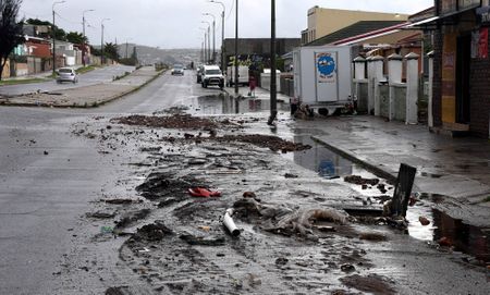
The destruction in the Kouga Municipality was not isolated. Across the broader Southern Cape, the same system was overwhelming infrastructure and cutting off communities.
In the Bitou Municipality, engineers are racing to repair critical infrastructure after up to 250mm of rain fell in parts of the region, threatening the water supply to Plettenberg Bay. The Uplands Water Works on the R340 – which supplies about 80% of the municipality’s water — was “severely affected” by flooding and remained inaccessible on Thursday afternoon, according to Garden Route District Municipality head of disaster management Gerhard Otto.
Adding to the pressure, the Roodefontein pump station was also flooded, while access to the Nature’s Valley pump station has been compromised. Bitou, which remains under a declared drought emergency with level four water restrictions, is relying on boreholes and the Plettenberg Bay desalination plant as fallback systems. The municipality estimates that reservoirs could sustain supply for “at least a day”.
Further inland, the town of Wittedrift, about 15km from Plettenberg Bay, was cut off for most of Thursday after the Bitou River flooded, leaving it without water and electricity. Otto said all residents were safe, with no medical emergencies reported, but both schools in the area would remain closed on Friday.
Across the region, emergency services continued to respond to widespread disruption, with campers at the Berg Oord campsite near Oudtshoorn unable to be evacuated due to persistent flooding, although a helicopter remained on standby. The Garden Route District Municipality said the N9 between Uniondale and George had reopened by Thursday afternoon, while alternative water supply measures were being arranged for Uniondale after a pipeline was washed away.
Storm posts dominated social media for most of the day.
The only fatality recorded during the storm so far occurred in Knysna on Wednesday, when a tree uprooted by wind and rain fell onto a vehicle, killing social development worker Lauren Fredericks (37). The Western Cape Education Department said 29 schools, mostly in outlying areas, would remain closed for a third day on Friday due to storm damage and blocked access roads.
The cut-off low weather system responsible for the widespread disruption has since moved offshore into the south-east Atlantic. While showers are still expected over parts of the Garden Route, the intensity of the system has eased, with conditions gradually stabilising. DM