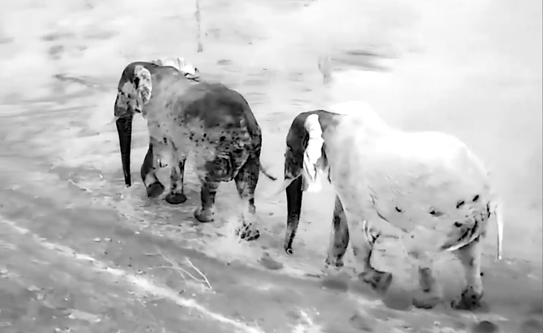
 Thermal imaging cameras detect the heat from animals, making it possible for wildlife managers to monitor their movements at night. In this image, the elephant on the right has just emerged from a wet mud bath, partially masking its heat signature and giving it a ghostly white appearance. (Photo: Carel Verhoef)
 Whether it’s tracking down rhino poachers at night, pinpointing the nests of endangered vultures or shepherding crop-raiding elephants away from farmers’ fields, South Africans are taking full advantage of advanced AI technology, drones and thermal imaging in conservation management projects across Africa.
Last year, South Africa-born conservationist and safari company owner Carel Verhoef deployed a small fleet of drones and ranger pilots to move a herd of 150 elephants — at night, for 70km — near the border between Tanzania and Kenya. He has also used drones to “buzz” predatory lions away from Maasai cattle bomas.
Closer to home, Johannesburg-based entrepreneur Willem Kellermann and his team of tech fundis at the Chisl/Veriphy AI group recently completed a major drone-based wildlife census covering more than 100,000 hectares in several private game reserves near Kruger National Park.
During the Project Gaia wildlife census in the Sabi Sands, Timbavati, Kwandwe and Karongwe reserves, Kellermann’s team captured nearly three million high-resolution images (at a rate of five every 0.7 seconds), after which they used machine-learning technology and a battery of Nvidia graphics processing units to identify and map the precise location of more than 50 wildlife species.
/file/attachments/orphans/tonydrone12dronesunset1imageSupplied_676140.jpg "The drones used in the Project Gaia census had to operate at temperatures exceeding 40 degrees and wind speeds of up to 50 km/h. The nine-day census followed months of planning, including obtaining landowner approvals and appointing qualified drone pilots. (Photo: Supplied)")
In the Hluhluwe/iMfolozi Park rhino-killing hotspot in KwaZulu-Natal, anti-poaching teams are also relying on drones, AI and thermal imaging cameras to track down and confront armed poachers in the pitch dark.
Elsewhere in the province, Ezemvelo KZN Wildlife scientist Dr Debbie Jewitt spotted the potential advantage of such tools almost a decade ago and qualified as a Beyond Visual Line of Sight (BVLOS) drone pilot. Since then, she and her research colleagues have applied their skills to several projects, including a mission to track down the “loneliest plant in the world” using drones, satellites and spectral imagery.
Kazi ya Tembo project (Tanzania)
In several parts of Africa, conflict between farmers and wildlife has increased over recent decades, leading to the establishment of “Kazi ya Tembo” (Working with Elephants), a Tanzania-based organisation that uses drones and thermal imaging cameras to reduce conflict levels.
/file/attachments/orphans/tonydrone2CarelVerhoefphotosupplied_335027.jpg "South Africa-born safari operator Carel Verhoef is leading and training Tanzanian wildlife rangers to track and shepherd elephants that wander too close to the shambas of local subsistence farmers. (Photo: Supplied)")
Carel Verhoef, who grew up in the Kruger National Park before moving to Tanzania in 2003 to establish safari camps in the Serengeti with Sally Grierson, explains that most crop-raiding happens at night — making it essential to find practical solutions that can be deployed in often pitch-black conditions.
This is where thermal imaging comes in. When deployed at night, the drone-mounted cameras can easily detect the massive heat signature emanating from a bull elephant weighing up to six tonnes.
/file/attachments/orphans/tonydrone4controlscreenphotocarelverhoef_414208.jpg "A ranger monitors elephant movements from the control panel of his thermal imaging system. (Photo: Carel Verhoef)")
Verhoef and his teams then use the high-pitched sound of the spinning drone propellers to shepherd crop-raiding elephants away from human settlements and towards neighbouring national parks.
Last year, they moved more than 150 elephants from the Goha sisal farms back to the Mkomazi National Park. This remarkable operation between Conservation Through Tourism, Kazi ya Tembo teams and the Tanzania National Parks Authority (Tanapa) involved moving them nearly 70km over five days and nights, mostly in darkness.
Verhoef notes that in comparison to helicopters, light aircraft and vehicles on the ground, drones provide a more cost-effective and “peaceful” solution.
“The calves get tired when moving over such long distances, so we spaced out the operation over several days to allow them adequate time to rest, feed and drink.”
/file/attachments/orphans/tonydrone3raidingelephantphotocarelverhoef_319352.jpg "Drones and thermal cameras have become vital tools to reduce human-elephant conflict in northern Tanzania. (Photo: Carel Verhoef)")
Over the past year, Kazi ya Tembo has conducted more than 2,000 drone flights and in excess of 1,300 emergency call-outs, successfully moving elephants away from farms in over 1,600 interventions in the Mkomazi landscape.
Grierson says this approach is non-invasive and focused on guiding elephants towards safe areas or corridors, rather than confrontation.
“A key part of the work is building trust with communities — shifting from reactive measures (noise, fire, chasing) to coordinated early warning and active management of elephants near human settlements. Over time, this has reduced crop loss, improved safety and allowed farmers to harvest successfully in areas that previously experienced frequent conflict,” she said.
The methodology is still evolving, but is now showing strong potential as a practical and scalable tool in landscapes where people and elephants share space, said Grierson.
/file/attachments/orphans/tonydrone6KaziyaTembo-Mkomaziteamphotocarelverhoef_207525.jpeg "Kazi ya Tembo rangers and drone pilot team members, (from left) Emmanuel Tembo, Zebadia Mmbando, Mathayo Daniel Namkesa, Derick Nelson Sandi and Raphael Killenga. (Photo: Carel Verhoef)")
Verhoef is happy that young men in the community now have time to play soccer during the afternoons or at weekends, freed from the dangerous and gruelling task of chasing elephants from their family shambas (farming plots) at night.
“The bottom line is that if everyone has food, conservation staff have a better chance of negotiating movement corridors for elephants. We need active and reliable management measures if we want to ensure open ecosystems. You can’t just move elephants 100 metres away from a farmer’s field — otherwise you are just transferring the problem to the neighbours.”
But don’t such large and intelligent animals lose their fear of the buzzing drones?
Verhoef suggests that the method is effective with roughly 97% of elephants, but he acknowledges that a small percentage, mostly bulls, can be stubborn.
In such cases, the Kazi ya Tembo pilots deploy two drones to apply more pressure from different angles. They have also modified the size and shape of the propellers to alter the noise pitch. In rare cases, they resort to fitting flashing lights on the drones or deploying ground-based rangers to fire pepper spray in the vicinity to flush the more recalcitrant animals out of thick vegetation.
/file/attachments/orphans/tonydrone5CarelwithSpanishAmbassadorPalomaSerraandvillagegamescoutJamesMsuyaphotosupplied_618667.jpeg "Carel Verhoef (centre) demonstrates his thermal imaging equipment to the Spanish ambassador to Tanzania, Paloma Serra Robles (left), and Tanapa village game scout James Msuya. (Photo: Supplied)")
“After two years of doing this, we have become pretty effective. But we also know that we have to be available to deal with problem encounters. Even if you are effective 90% of the time, that is still a failure if you aren’t around for the other 10% of the time. If you cannot secure people’s harvests and establish trust, you may as well not do this work.”
More recently, Verhoef’s team has also used drones to drive lions away from cattle bomas.
“Hungry lions are harder to deter, especially in the dry season when they become quite desperate, but by maintaining regular pressure from different angles and altitudes, they eventually get the message and return to their normal diet of wild animals.”
Project Gaia (South Africa)
Back in South Africa, the Chisl and Veriphy AI groups recently completed a ground-breaking wildlife census and mapping survey in the Timbavati and Sabi Sands reserves, known as Project Gaia.
It involved much more than strapping a few cameras onto drones and then counting a multitude of images.
In this case, Willem Kellermann, Dirk Strauss, Johan Dannhauser and fellow staff harnessed a variety of tech tools (including AI, computer vision and machine learning) to automate the identification and counting of thousands of wild animals from more than 50 species.
/file/attachments/orphans/tonydrone8DroneandCruiserphotoVeriphyAI_696056.jpg "A powerful VTOL drone takes to the sky during the Project Gaia wildlife census in Sabi Sands private game reserve. (Photo: Veriphy AI)")
In simple terms, AI computer models were trained to recognise several animal species, many of them hidden or obscured beneath thick vegetation.
Using computer vision, the machines were taught to distinguish between a kudu and an impala, for example, based on their coat patterns and other unique features — a daunting task, considering that they were spread over more than 100,000 hectares.
/file/attachments/orphans/tonydrone9buffalotimbavatiphotoVeriphyAI_848742.jpg "A large herd of buffalo slake their thirst at a watering hole in Timbavati private game reserve. (Photo: Veriphy AI)")
/file/attachments/orphans/tonydrone10insetshowingsamescenewithshowingAItaggedbuffalophotoVeriphyAI_158885.jpg "A close-up view of the same herd showing buffalo “tagged” by AI and machine learning technology. The numbers represent identification confidence levels for each animal. (Photo: Veriphy AI)")
Timbavati wildlife managers report that this census method is more accurate than traditional manned aircraft surveys. It also offers lower costs and significantly reduces disturbance to wildlife and tourists.
The drones flew at relatively low altitudes and were equipped with advanced camera lenses, enabling the team to gather images of a much higher resolution than those provided by satellites.
Another unique feature was that instead of having a single downward-facing lens, most of the drones had five lenses — one pointing straight down to capture a plan view, with the remainder pointing in the four cardinal directions to provide oblique views.
By providing this variety of side views, AI models were able to detect more animals, particularly when only the flanks or other portions of their bodies were visible through dense vegetation.
Colin Iles, a Cape Town-based business consultant who followed the project closely, said he was struck by the fact that only 20% of the animals were identified by plan-view images alone. Most were identified from the oblique views.
‘I think this is a fabulous example of South African entrepreneurship at its best, comparable to the best of Silicon Valley.”
Whereas traditional census methods rely on skilled human observers counting animals manually, Project Gaia had the benefit of nearly three million images taken every 0.7 seconds, along with GPS locations of every frame.
Getting scientists to interpret that volume of images would be an impossible task, but Kellermann’s group had support from Amazon Web Services, which provided eight H200 GPUs to process the images.
Project Gaia in numbers
• 100,000 hectares covered
• 2,850,000 images were taken.
• 30TB of data was generated and 78 trillion pixels analysed.
• 8 x H200 Nvidia GPUs were used for processing.
• More than 20,000km of straight-line flying.
William Hodgson, acting conservation manager of the 44,000-hectare Sabi Sands reserve, describes the technology as a “game-changer”.
“For the last 30 years or so,” said Hodgson, “we have been doing an annual census from the back seat of a helicopter. It’s a great tool, but it’s expensive and noisy, and the number counts are subject to human error.
“I’m not bashing helicopters, but the difference between them is chalk and cheese in terms of noise and disturbance to both guests and animals. You barely notice the presence of the drones.”
Apart from enabling more accurate animal counts, Hodgson says the survey captured additional vital data, including the locations of vulture nests, watering points and road networks, and the condition of trees — specifically those protected by wire wrapping against elephant damage.
He believes such data will help save time and money, freeing conservation staff to concentrate on other management or research projects.
Conservation managers at Timbavati expressed similar excitement about the results of the first survey, citing the greater accuracy in estimating game numbers spread over vast areas.
/file/attachments/orphans/tonydrone11taggedrhinoandhippophotoVeriphyAI_456632.jpg "Through AI computer vision and machine learning, animals with similar shapes and sizes can be distinguished clearly. (Photo: Veriphy AI)")
A further environmental benefit is that drones have electric motors fuelled by solar power and don’t burn through drumloads of fossil fuels.
One disadvantage of current AI models, however, is that they are currently unable to determine the sex of an animal or differentiate between small antelope species (such as duiker, steenbok and klipspringer), instead defaulting to a broad “small antelope” classification. Further training will enable them to overcome these data gaps.
Dr Debbie Jewitt, a senior conservation scientist at Ezemvelo KwaZulu-Natal Wildlife, says she was “astonished” by the level of detail gathered in Project Gaia, saying that drones and AI have the potential to revolutionise conservation and spatial ecology studies.
Jewitt, a qualified drone pilot who has pioneered the use of drones in Ezemvelo’s conservation work, said: “What they have achieved is amazing. The level of high-resolution data that was captured is just astonishing, and I’m green with envy.
“Traditional manual counting methods just cannot compete with drones and AI, especially with large landscapes. I would love to be doing similar work at this scale, but collecting and analysing such a large volume of data is currently beyond the technological and resource capacity of local conservation agencies. We just don’t have that level of computing power or storage capability.”
Jewitt emphasises the need to minimise disturbance, especially with sensitive species. Though drones are much quieter than helicopters and aircraft, they can still cause disturbances based on their size, shape, colour, altitude and propulsion systems.
She notes that fish eagles, crows and falcons have attacked or harried drones, though pelicans and yellow-billed storks (which are communal nesters in large noisy colonies) appeared unfazed. She has seen a giraffe mother and calf fleeing after spotting a drone 80m away, while there are accounts of hippo and crocodile moving away or diving underwater when disturbed by drones at close quarters.
Jewitt has written a chapter in Drone Professional 2, providing a detailed set of guidelines to avoid wildlife disturbance during such flights. DM