


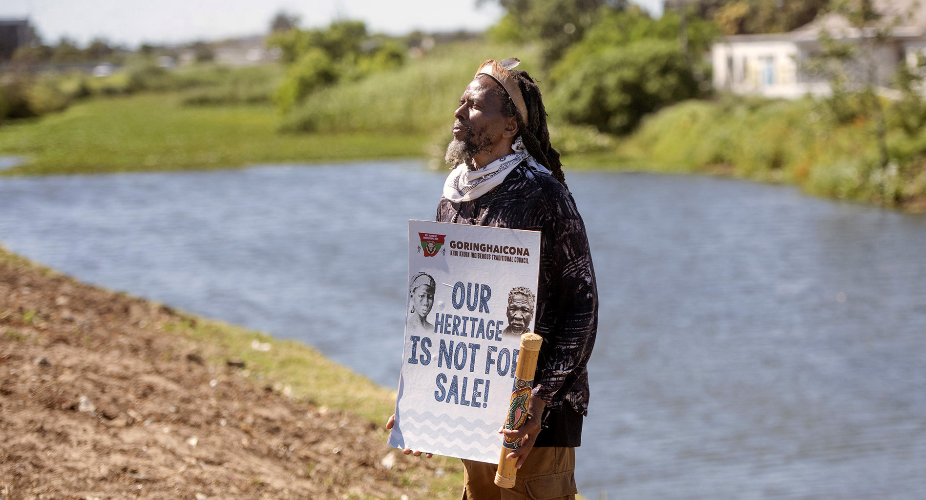
 Protestors during the Liesbeek Action Campaign against the River Club Development on November 12, 2021 in Cape Town, South Africa. It is reported that indigenous and heritage protection and conservation groups with concerned residents have slammed the development citing that it is a destruction of a sacred heritage site that deeply violates climate change policy, including the Paris Agreement. (Photo: Gallo Images / Brenton Geach)
 It is significant that the early colonial history of the Cape has again become a battleground of ideas. Clearly, history is not dead — moribund rather are those interpretations that succumb to old relations of power and don’t look to nurturing a more resilient future.
A case in point is that of the development of the River Club site which includes the confluence of the Two Rivers (Liesbeek and Black) — itself once witness to an iconic struggle. Here the early and most important wars of resistance were fought by indigenous Khoe against the newly arrived Dutch colonists. Today, the River Club, an integral part of the area, is being decried and dismissed by some as a wasteland and marsh — as historically insignificant and not worth the fight to mark, remember and hold dear.
A place of home
/file/dailymaverick/wp-content/uploads/2022/07/MC-Liesbeek-Meltzer.jpg "Men, women and children – arriving to set up summer villages in the CapePeninsula. (Source: National Library of South Africa)")
The earliest Cape farm grants by Jan Van Riebeeck were made along the Liesbeek, an area that generally offered better protection against the wind and had perennial water. It was the reason the pastoralists had arrived there every summer with their women and children, huts and herds of cattle and fat-tailed sheep, as they had done for hundreds of years.
In November 1652 Van Riebeeck’s men returning to the fort reported that they had seen a multitude of cattle and sheep in the vicinity of the Liesbeek River and remarked on how hospitably they were received by the people with offerings of fresh milk in their homes made of mats. In those early years, Van Riebeeck frequently recorded the arrival of the tribes at the Salt River and Liesbeek, at times moving on to Hout Bay and Constantia and sometimes — though not often enough in his view — making their way to the fort in town with a carefully studied reluctance to exchange their animals.
In November 1655 he and his men described, with a degree of amazement, how the land stretching inland from near the mouth of the Salt River was on an occasion filled with so many cattle and sheep that it was difficult to estimate the numbers present or to see the ground. The attraction of the land lay in the wetlands, vleis and rivers which fed the summer pasturages.
In January 1660 leading Khoe chiefs, attesting to their precarious situation, declared their land rights to Van Riebeeck, stating that the Cape was their birthplace and their own country — and highlighting the absence of what they had once had which was an abundance of fresh water. (Journal, Jan van Riebeeck, vol. I, 21 November 1652, p. 100-1; 18 December 1652, p. 116; 24 November 1655, p. 369-70; vol. III, 18 January 1660, p. 176-7)
A place of farms: Van Riebeeck’s farm on the Liesbeek
As early as 1656, Van Riebeeck informed the Goranhaicona chief, Autshumato, and Gogosoa, chief of the Goringhaiqua, that all their land between Lion’s Head and the Windberg (Devil’s Peak) was to be reserved for the Dutch settlement. Precisely a year later the Table Bay settlement was expanded to the fertile Liesbeek valley east of Table Mountain. (Dan Sleigh, Die Buiteposte (1993), p. 40-1)
Records in the archives confirm how many of the new properties granted as private property to the new settlers — on the lands of Khoe pasturages and villages — had taken a length of the Liesbeek River as a border — from Bishopscourt to Observatory.
And contrary to what has been declared, one of these earliest farms covering much of the Liesbeek area in Observatory, included a significant part of the disputed River Club site. It was granted to Jan Reijnierssen and Wouter Cornelis Mostert in 1657 and, after a change from Mostert to Cornelis Claesz, both parts passed to Van Riebeeck himself. In the archives is a drawing of the property attached to a transfer of the land in 1659 identifying and describing its position across both banks of the river (“aen de West ende Oostzijde van de verse reviere Liesbeecq”). (WCARS, VC39 vol. III, 15 May 1659)
Another early plan (from the Dutch National Archives) showing all the early farms granted to Cape free burghers drawn in c. 1660 shows the farm marked with “33” (morgen), lying on both banks of the Liesbeek, and including part of the area of the River Club. The plan identifies it now as Van Riebeeck’s land (“Commandeurslanden”) — see the illustration below. (Rijksarchief, VEL. 808)
The farm was named Den Uijtwijck and continued during its subsequent ownerships to incorporate the Liesbeek River which is described as running through it. (Deeds Office, Cape Town, Summary of Transfers: Jan van Riebeeck, Theilman Hendricx, Jan Verhagen and Jan Mostert) Being so early and enormous, it was then subdivided and transferred in a complex process of subdivision with a large part of it becoming known over time as Malta. Today the remnants of the old farm name can be found in the office block and playing fields of Malta in Observatory on Liesbeek Parkway.
Farming development
Farming activities on Uitwijck consisted both of grain cultivation and cattle and sheep, which was a common pattern, undertaken by the labour of enslaved men, women and children at that time largely from Angolan and Guinea areas of West Africa (but increasingly over the years from south-east Asia, India and eastern Africa) — supervised by men from Europe. Resistance by the first enslaved people was almost immediate on their arrival at the Cape. Indeed, in June 1658, all four of the enslaved men and women working on the farm owned by Reijnierssen managed an escape with blankets, clothing, rice and tobacco — helped on that occasion by some of the Peninsular Khoe. (Journal Van Riebeeck, vol. II. 21 June 1658, p. 286-291)
Reijnierssen’s portion of the land seems in the main to have covered the western side of the Liesbeek, (Anna Böeseken, Jan van Riebeeck en sy gesin (1974), p. 255) though mention is also made of his cattle grazing on the other (or eastern) side of the river. (Journal Van Riebeeck, vol. III, 20 My 1659, p. 50) There are several references to his cattle trading on the farm which confirm his own cattle keeping. In 1657 Van Riebeeck reported that a group of Cochoqua people had decided to stay the night at Reijnierssen’s house, keeping their cattle in his kraal, and making their way to the fort the next day to trade with Van Riebeeck. A few years later in 1660, there is reference to barley growing on the farm and in 1661 of reaping ripe barley. (Journal Van Riebeeck, vol. II, 24 October 1658, p. 359-60; Journal of Jan van Riebeeck, vol. II, 29 October 1657, p. 169; vol. II, p, 29 October 1667, p. 169; vol. III, 25/26 October 1660, p. 275; vol. III, 15 November 1661, p. 435)
/file/dailymaverick/wp-content/uploads/2022/07/MC-Liesbeek-Meltzer_1.jpg "Van Riebeeck’s farm on the Liesbeek (33) on both sides of the Liesbeek River and including part of today’s River Club site. (Source: National Archives, Netherlands)")
The confluence of the two rivers provided the wider environmental context for the farmland that lay on the eastern bank of the Liesbeek. The wetlands that fed the biodiversity of the area, drying up in parts during summer, would have provided areas of grazing as they had done for the pastoralists. Interestingly, after an inspection of the new farms in October 1657, Van Riebeeck mentioned the success of the rice harvest sown in the marshy land east of the Fresh River (Liesbeek) opposite the farm of Hendrik Boom, a neighbour of Uijtwijck (and probably part of later Bellevliet). (Journal Van Riebeeck, vol. II, 7 October 1657, p. 156) Dutch officials and burghers clearly were experimenting with various crops on different types of terrain but, whatever the conclusions, they were determined to evict the pastoralists from their ancestral land of the rivers.
/file/dailymaverick/wp-content/uploads/2022/07/MC-Liesbeek-Meltzer_2.jpg "Bowler’s view of the Liesbeek River, with young Muslim men (one wearing a toering) –Cattle grazing along the river in the foreground with a side view of theRoyal Observatory and one of the local windmills in the background,c. 1840s. (Source: Iziko Museums, Social History)")
Uitwijck farm on the other side of the Liesbeek and the area of the confluence of the two rivers was a major first call of the indigenous pastoralists as they entered from inland often at the Salt River crossing near today’s Montagu Bridge in Maitland. The soon-to-be fortified farmlands therefore immediately blocked access to their ancestral lands. Thus, it was that the farms along the Liesbeek very soon became the subject of attrition by skilled Khoe fighters. Van Riebeeck’s journal records on many occasions how the pastoralists eluded VOC soldiers and settlers in fast and nimble movements crossing the rivers and hiding in the bushes on the lower slopes of the nearby Windberg (Devil’s Peak) — and then disappearing safely into the interior.
A place of dispossession and military repulsion
It was no coincidence therefore that the main part of the military fortifications to repulse the Khoe from their lands was built on the land of rivers. The redoubts, watch houses and forts were constructed in a long line from the vicinity of the Salt River mouth to the upper reaches of the Liesbeek near Bishopscourt and Kirstenbosch. A VOC historian has drawn a diagram of the probable positions of the fortifications calculating that its middle watch house, Ruijterwacht, rebuilt in 1664, was on the hill on which the Royal Observatory stands today (next to the River Club site) or slightly further towards some of the higher area of Valkenburg farm, both in present Observatory. Its purpose was to overlook and secure the farms in the area and to regulate expeditions to the interior. By 1672, its corporal appeared to be in charge of the spine of fortifications. Several years later in 1697 Ruijterwacht was still standing and is referred to in the records as a place of detention for the Asian political exiles and noblemen banished from Dutch-controlled Macassar who had been living at Rustenburg. (Dan Sleigh, Die Buiteposte (1993), p. 128fff)
Located on the Liesbeek, Reijnierssen’s farm was ideally located to undertake a private cattle trade with the Khoe pastoralists. In December 1657 Van Rieebeeck noted: “The freemen again obtained a cow and a calf at the house of Jan Reijnierssen, situated about an hours’ walk from the fort and right in the path of the Hottentots at the Fresh River, very suitable for trade.” (Journal Van Riebeeck, 16 December 1657, p. 193) Reijnierssen’s actions, however, soon became a hindrance to the Company and shortly afterwards this private trade was declared illegal. In 1658 Van Riebeeck noted Reijnierssen was again engaging in the forbidden cattle trade. He records now that Reijnierssen was detaining Khoe people at his house on the road to the fort, so that the animals seldom reached the fort without his obtaining at least some by fair means and also by force. He went on to relate the pastoralists’ complaints about Reijnierssen, who invited them to his house, and when they refused to agree to his terms became violent and seized their property. (Journal Van Riebeeck, vol. II, 24 October 1658, p.359)
It was also at Reijnierssen’s house that Gogosoa, high ranking chief of the Goringhaiqua, was detained in 1658. After the cattle of another neighbouring farmer, Hendrik Boom, had been taken by the Khoe, Jan Reijnierssen seized Gogosoa. Chief Gogosoa who was large and unable to walk well was kept at his house though orders came from the fort to treat him well. A few years later, in 1660, a group of Khoe men complained about their cruel treatment by the free burghers, particularly Reijnierssen and his neighbour Boom. They accused the farmers on this occasion of having strung up a man by a rope in one of the farmhouses. (Journal Van Riebeeck, vol. III, 18 January 1660, p. 176)
Over the subsequent years, with fences and hedges, here and there steepened embankments, gates and watch houses, and with the aid of guns and horses, Van Riebeeck’s soldiers expelled the Khoe people from their lands in the Peninsula. It is a story of heroic resistance, and highlights the disaster of colonisation which led to the disintegration and annihilation of Khoe society. The Liesbeek, including the River Club site, is a place of national memorialisation.
Integrity of the Two Rivers
- The area of the Two Rivers is what is left of the once extensive places of home of the Khoe in the Peninsula and adjacent areas. The Two Rivers is the only recognised remnant — much of the rest has been buried and forgotten under suburban residential or office development.
- It is clear that what is left is inextricably connected to the two rivers — the Liesbeek and Black — their courses, streams, marshes and pools, embankments and their confluence to form the Salt River.
- The integrity of the Two Rivers land arises from the need to protect both the environment and intangible heritage.
- The importance of the River Club site likewise lies in its context as an integral part of the Two Rivers site, constituting the last bit of the heartland of the Liesbeek River before joining with the Black River to form the Salt River and making its way along highways, among industries, warehouses and container depots.
- The area cannot be further damaged by the development of concrete towers and dividing up the remaining land into parcels of so-called greater and lesser heritage or environmental importance, based in fact on the short-term needs of private profit and state coffers.
/file/dailymaverick/wp-content/uploads/2022/07/MC-Liesbeek-Meltzer_3.jpg "Dancing Khoe women. (Source: National Library of South Africa)")
A place of memory: restoring the environment
The lands of the rivers were of core social and economic importance to Khoe people and continue still today to bear meanings of spirituality and identity, linked to memory, orality and intangible history. It is not easy to separate indigenous linked meanings of environment and heritage. Where else better to celebrate all indigenous people’s connections to water, nature and the environment but on the Two Rivers site.
The City’s own Spatial Planning and Environmental Management Department professionals appealed the decision for the development on the River Club to go ahead (and were ignored) citing several reasons, including:
- insufficient mitigation of stormwater impacts, including flooding;
- due consideration not given to climate change impacts and resilience;
- not appropriately describing, or mitigating, the loss of open space; and
- and not appropriately describing or mitigating the high negative biodiversity impact or habitat loss of a high faunal sensitivity. (Kevin Winter - https://www.news.uct.ac.za/article/-2021-11-10-alarming-precedent-liesbeek-river-under-siegeagain
/file/dailymaverick/wp-content/uploads/2022/07/MC-Liesbeek-Meltzer_5.jpg "A battle is raging over the proposed development of the land along the Liesbeek River in Cape Town. (Archive photo: Ashraf Hendricks)")
The fight to preserve the River Club site must rise above petty point-scoring and parcelling out the powerful story of indigenous dispossession. It provides us all with the challenge of finding new ways to secure community needs in a time of ecological disaster; to energetically undertake custodianship of our part of our place on earth. The treachery of concrete towers on a floodplain must be put right. The whole area of the Two Rivers should be graded as a national heritage site that operates in support of the environment. DM/MC
Lalou Meltzer is retired but was director of Social history at Iziko Museums and was on the board of the D6 Museum.